


Ardmore, County Waterford, is a village steeped in history and culture, and its place names tell fascinating stories that reflect the area’s rich heritage. From ancient monastic origins to natural landmarks, the names of places in Ardmore provide a glimpse into the past and the significance of the land. Let’s explore some of these captivating place names and their meanings.
A Journey Through History
Ardmore derives from the Irish “Aird Mhóir,” meaning “the Great Height.” This name fits a village boasting stunning cliffs and panoramic views of the Atlantic Ocean. Historically, Ardmore was known as “Ard na gCaorach,” or “Height of the Sheep,” reflecting its pastoral roots and agricultural significance.
As you stroll through Ardmore, you’ll encounter a variety of intriguing place names that evoke curiosity and wonder:
- St. Declan’s Well: Named after the village’s patron saint, this holy well is a site of pilgrimage and reverence. It symbolizes the deep spiritual connection that the community has with its history.
- The Cave of the Wild Cats: This evocative name hints at the natural wildlife that once roamed these lands. It invites visitors to imagine a time when wild cats prowled the cliffs and caves of Ardmore.
- The Well of the White Cow: A name steeped in local folklore, this well adds an element of mystique to Ardmore’s landscape. It reflects the importance of cattle in Irish culture and agriculture.
- Stinking Corner: This unusual name may raise eyebrows, but it likely refers to a specific location known for its unique characteristics or an old fishing spot where seaweed would wash ashore.
The Townlands of Ardmore
Ardmore is divided into several townlands, each with its distinct name and story:
- Ahaun (Áthán): Meaning “Little Ford,” this area is rich in natural beauty and history, with sub-denominations like Cloch Áthán, or “Little Ford Stone,” marking significant landmarks.
- Ardoginna (Ard Ó gCionáith): Translating to “O’Kinny’s Height,” this townland features stunning coastal views and historical significance tied to local families.
- Ballinamona (Baile na Móna): Meaning “Homestead of the Bog,” this townland reflects Ardmore’s agricultural roots, with fertile lands that have sustained generations.
The Legacy of Place Names
The place names in Ardmore serve as geographical markers and as reminders of the village’s rich cultural tapestry. They encapsulate stories of saints, nature, and local legends that have shaped the identity of this coastal community.
Rev. Canon Power once noted how these names provide insight into Ardmore’s ecclesiastical importance and its unique geographical features. The variety of cliff names, ecclesiastical sites, and unusual designations contribute to a deeper understanding of how people have interacted with this landscape over centuries.
Conclusion
Exploring the place names of Ardmore is like embarking on a journey through time. Each name carries a story—a connection to the land, its people, and its history. As you wander through this enchanting village, please take a moment to appreciate the meanings behind these names, allowing them to enrich your experience in Ardmore.
Whether you’re visiting St. Declan’s Well or standing at Stinking Corner, you’ll find that each location invites you to connect with the past while enjoying the stunning beauty of County Waterford. So discover Ardmore—where every place name holds a piece of history waiting to be uncovered!
Citations:
[1] https://www.ardmorewaterford.com/placenames-of-ardmore-waterford/
The Remarkable Place-Names In Ardmore
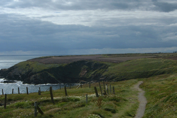
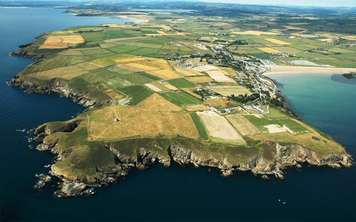
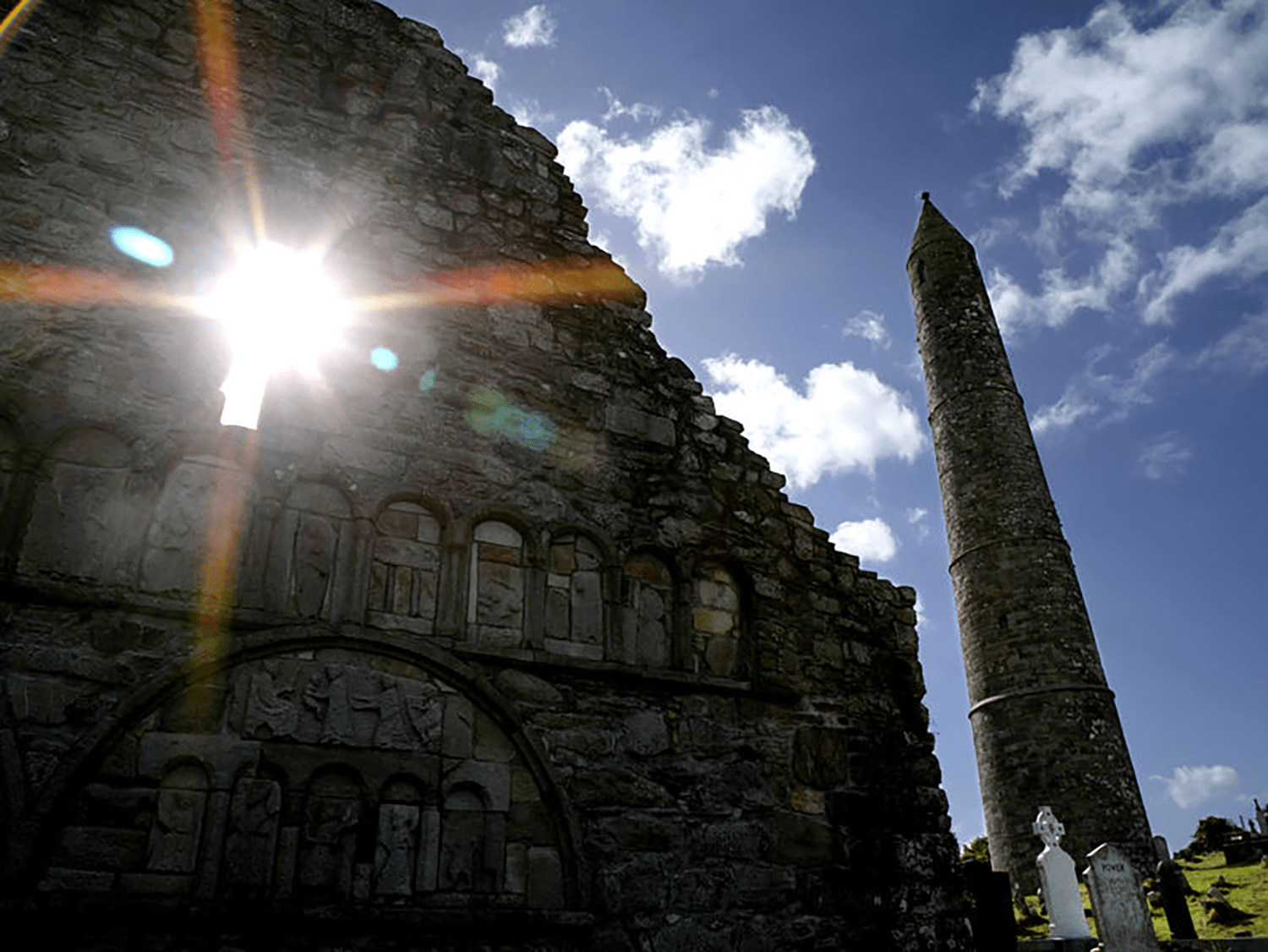
From the 29 meter Round Tower with a watchful eye over the bay to Saint Declan’s Well and cliff walk, Ardmore is an invitation that is hard to refuse. Learn about some of the remarkable place names in Ardmore and be amazed by the secret meaning behind this wonderful portion of the world.
Ardmore Waterford offers so much more than a city break.
And, walking around Ardmore, you’ll be amazed at the beauty of this little seaside hideaway.
Dig a little deeper, and you may even stumble upon something unusual. Discover the “Well of the White Cow”? Stare at the “Stinking Corner”. And even seek out the “Cave of the Wild Cats”.
For something a bit different, step back in time and let Rev. Canon Power be your guide to the placenames of Ardmore.
What’s In A Name?
Ardmore was an ancient monastic and episcopal parish – it is maritime – of great extent and curiously broken up into isolated fragments.
Historically, it has been one of the most important parishes in the county – if not, indeed, in Ireland. From our present special point of view also, it is exciting. It furnishes many cliff names, some ecclesiastical names of value, and many unusual names and forms. St. Declan established himself here, probably in the 5th century and before the advent of St. Patrick. The chronology of Declan’s life is singularly complicated and uncertain. The ecclesiastical remains at Ardmore consist of a Cathedral, a Round Tower, and a primitive oratory, and, at a distance of a quarter of a mile from the main group, stands a second early church with holy wells, &c.
There is likewise the site of a castle, frequently referred to in connection with the 17th-century wars. For a detailed description of the cathedral, tower, oratory, &c. see “Ardmore Deugláin.” (Cath. Truth Society of Ireland). Ardmore (Ard mhór “the Great Height”), is the name of the parish only. An older name according to St. Declan’s Life was Ard na gCaorach – “Height of the Sheep.” Ard na gCaorach, as a place name, still survives; it is occasionally applied to that portion of the parish lying generally to the south of the main road which runs from Ardmore village to the sea at Whiting Bay. Within the specified area are roughly comprised of the townlands of Ardocheasty, Ardoginna, Farrengarret, and Ballinamona.
The village of Ardmore is spread over the adjoining portions of four townlands – Duff-Carrick, Dysert, Farrengarret, and Monea. That wonderful industrialist, the Great Earl of Cork, developed an extensive pilchard fishery at Ardmore. In 1616 he erected a fish press and built salting and fish houses, all of which have long since disappeared. Local speakers of Irish pronounce the name, Aird Mhóir.
Townlands of Ardmore:
AHAUN: Áthán – “Little Ford.” Area 128 acres.
Sub denominations (S.D):
(a) Cloch Áthán – “Little Ford Stone”; a large pillar stone standing prominently on the summit of a bare ridge and visible for miles around.
(b) Áth na gCéim – “Stepping-Ford.”
ARDOCHEASTY: Ard Uí Shéasta – “O’Cheasty’s Height.” This was ancient chantry land. Area 172 acres. The present writer has edited, from the original at Brussels, Brother Michael O’Clery’s “Life of St. Declan” Irish Texts Society, 1916) “Life and Letters of the Great Earl of Cork” (Townshend), p.101 “Archeolesty” (Distr. Bk.).
Sub denominations (S.D):
(a) Poulnagat (Ordnance Map), Poll na gCat, also Faill na gCat – “Cave (and “Cliff”) of the Wild Cats.”
(b) Leaca Dhóite – “Burned Glen Slope.”
(c) Páirc na Scolb – “Field of the Splinters (Skewers for thatching).”
(d) Faill an Duilisc – “Cliff of the Edible Seaweed.”
(e) Bóithrín an Deantaigh – “Meaning uncertain. Possibly Deantach is a personal name.
(f) “The Curring” – Meaning unknown; on boundary with Dysert.
ARDOGINNA: Ard Ó gCionáith – “O’Kinny’s or Kenna’s Height.” Area 425 acres.
Sub denominations (S.D):
I. Coastwise: (E. to W.).
(a) Gleann Phiarais – “Pierce’s Glen.”
(b) Faill na nGairdíní – “Cliff of the Gardens.”
(c) Gaibhlín an Phuith (?) – “Narrow Sea Inlet of the Wind Gust.”
(d) Carraig Fhada – “Long Rock.”
(e) Gaibhlín an Chubhair – “Sea Inlet of the Froth.”
(f) Faill an Mhadra Rua “The Fox’s Cliff”
(g) Cois Céim – “Stepping Stone.”
(h) Cúil an Ghearráin – “The Old Horse’s Corner.”
(i) Falla Bán – “White Wall.”
(j) Faill na bPréachán – “The Crows’ Cliff.”
(k) Pointe an tSeaga – “The Cormorant’s Point.”
(l) Faill na Bó – “The Cow’s Cliff.”
(m) Poll na Gaoithe – “Windy Cavern.”
(n) Gaibhlín na Mealbhóg – “Narrow Sea Inlet of the Pouches.”
(o) Faill an Iarrainn – “Iron Cliff.”
(p) Faill na gCaorach – “Sheeps’ Cliff.”
(g) Gleann Beag – “Little Glen.”
(r) Gabhlín an tSeaga – “Narrow Sea Inlet of the Cormorant.”
(s) Cloch (or Croch) an Oidhre – “The Heir’s Rock (or Gallows).” The name is accounted for as follows. A young man, the heir of considerable property, had gained a certain lady’s affections. A jealous and disappointed rival contrived at a ball to put by stealth into the young man’s pocket a gold cup, which he then accused him of stealing. The accused fled on horseback and, being pursued, jumped his horse over Faill Fhada calculating the animal would fail to clear the chasm and that both would be killed. The horse, however, jumped the opening and landed on a piece of earth-covered rock at the other side. Here the young man took refuge in a cave, but was tracked by bulldogs, taken finally, and hanged at this place!
(t) Faill Fhada – “Long Cliff.”
(u) Carraig an tSasanaigh – “The Englishman’s Rock.”
(v) Clais na mBolamán – “Trench of the shad (Horse Mackerel).”
(w) Oileán na nGabhar – “The Goat’s Island.”
(x) Gaibhlín an tSagairt – “The Priest’s Little Sea Inlet.”
(y) Gort an Dúinín – “Garden of the Little Fort.” The “Fort” in question is an entrenched headland which the present place adjoins.
(z) Carraig Uí Bhric – “O’Bric’s Rock” ; uncovered at low water, as is the next.
(aa) Carraig Bhuí – “Yellow Rock.”
(bb) Carraig an Mhadra – “Rock of the Dog (Wolf).”
(cc) An Lochtaigh – “Cliff of the Ledges.”
(dd) Carraig Philib – “Philip’s Rock.”
(ee) Faill an Leanmhanaigh – “Cliff of the Pursuer.”
(ff) Faill na Cuaille Seasaimh – “Cliff of the Standing Pole.”
(gg) Faill an Reithe – “Cliff of the Ram.”
(hh) Faill na mBioránach – “Cliff of the Sprats,” or “ Sharp-pointed Rocks.”
II. Inland:
(ii) Tobairín an tSiúcra – “Little Well of the Sugar.”
(jj) Móineán Oidhre – “The Heir’s Little Bog.”
(kk) Bán an Rinnce – “Field of the Dance.”
BALLINROAD: Baile an Róid – “Road Homestead.” Area 202 acres.
BALLINTLEA: Baile an tSléibhe – “Mountain Homestead.” On this are the graveyard and ruined church of Ballymacart. Area (in two divisions) 290 acres.
BALLYCURRANE: Baile Uí Chorráin – “O’Currane’s or Carey’s Homestead.” Area 223 acres. “Ballycurryn” (Inq. Jas. I.).
Sub denominations (S.D.):
(a) Páirc na dTruiseanna (dTurasanna) – “Field of the Devotional Rounds.” See Journal R.S.A. (Ireland) Vol. XXXVI., pp.248-9
BALLYGUIRY: (See under Dungarvan par.) Area 261 acres.
BALLYKILMURRY: Baile Mhic Giolla Mhuire (also Baile Uí Mhic Giolla Mhuire) – “MacGillemory’s (or O’MacGillemorys) Homestead.” “MacGillemory, a leading Norse family in Waterford, was in later times said to have come from Devonshire.” Journal R.S.A.I. Sept. 1901, p. 302. Area 113 acres.
Sub denominations (S.D):
(a) Faill an Uisce – “The Water Cliff.”
(b) Faill na gCaorach – “Cliff of the Sheep.”
(c) An Bruachán – “The Little Bank (or Border)”; a bank of land running into the sea.
(d) Carraig na Rónta – “The Seals Rock.”
BALLYNAHARDA: Baile na hArda – “Homestead of the Height (Ridge).” Area 266 acres.
Sub denominations (S.D.):
(a) Faill an Chnoic Rua – “Cliff of the Red Hill.”
(b) Cabhar an Ime – “The Butter Causeway.”
(c) Rinn an Oileáin – “The Island Point.”
(d) Faill an Ghabhair – “The Goat’s Cliff.”
(e) Faill an Ghlíntín. See (d) under Ballinamona II below.
BALLYNAGLERAGH: Baile na gCléireach – “Clergy Town.” Area 98 acres.
BALLYNAMERTINAGH: Baile na mBirtíneach – “Homestead of the Small Bundles” (O.D. O’Donovan ?). Although this is O’Donovan’s interpretation, I regard it with considerable doubt. It seems much more probable that the qualifying word represents a family name, scil:- Martin or Merton. The Act (16 Chas. I.) for adjusting differences between the Earl of Cork and the Bishop of Waterford enacts that “the Castle in Ardmore lately built by Sir E. Harris with the two plowlands next adjoining called Carriggduffe and Ballymartinagh be made mensalls for ever of the Bishoprick.” Area 336 acres.
Sub denominations (S.D.):
(a) Áth na gClárach – “Ford of the Planks.”
(b) Tobar na Tuinne – “Well of the Quagmire.”
(c) Páirc na Scine – “Field of the Knife.”
(d) Páirc an Chlampair – “Field of the Contention.”
(e) Cnoc Airdín (now often bun an Chnoic – “Bottom of the Hill”) – “Hill of the Little Height.”
(f) Clais na Muc – “The Pigs’ Trench”; a ravine on the coterminous boundary of this townland with Ballybrusa and Ballylane.
BALLYNAMONA I: Baile na Móna – “Homestead of the Bog.” There are, strangely enough, two townlands of the name in the parish. Area (in two divisions) 464 acres.
Sub denominations (S.D.):
(a) Poll Rua – “Red Hole (Cavern)”; a sub-division of some 300 acres.
(b) Páirc na dTurcach – “Field of the Turks (or Turkeys).”
(c) Tigh Chaille Bhéara – “Caille Beara’s House”; this is a dolmen standing close to edge of the cliff.
(d) Faill an Ghlíntín. This is locally understood to mean “Cliff of the Streamlet.” There is a similarly named cliff on Ballinaharda, and in both cases the cliff so designated is between two small glens running down to the sea.
BALLYNAMONA II: Baile na Móna – “Homestead of the Bog.” This townland, of same name as last, is separated from the latter by some miles; they cannot therefore be regarded as portions of a common Ballynamona. Area 738 acres.
Sub denomination ( S.D.):
(a) Lisíní – “Little Lioses.”
BALLYTRISNANE: Baile Uí Thriosnáin – “O’Tresnan’s Homestead.” Area 281 acres.
Sub denominations (S.D.):
(a) Cill – “Church.” The name is here applied to two fields (formerly one) in which is an early church site and close to the latter – a Holy Well.
(b) Gleanntán an Mhadra – “Little Glen of the Dog (Wolf).”
(c) Tobar Thriosnáin – Still occasionally visited.
BARRANALEAHA: Barra na Léithe – “Summit of Leagh.” Leagh is the townland immediately adjoining, lower down the hillside. Area 123 acres.
BARRANASTOOKA: Barra na Stuac – “Summit (Height) of the Projecting Peak.” Area 419 acres.
Sub denominations (S.D.):
(a) Currach Cinn – “Swamp of the Head”; a well-known subdivision.
BOHERBOY: Bóthar Buí – “Yellow Road.” Area 212 acres.
CARRIGEEN: Carraigín – “Little Rock.” Area 46 acres.
CARRONAHYLA: Carn na hAidhle – O’Donovan renders it “Cairn of the Adze” and surmises that the monument marks the grave of a cooper. More probably Carn na hAibhle – “Cairn of Fire Spark (or ‘Electric Flash’ ),” or, “of the Wind” – also, Aidhle. Area 157 acres.
CARRONBEG: Carn Beag – “Little Cairn.” Area, 230 acres.
CARRONADAVDERG: Carn an Daimh Deirg – “Cairn of the Red Ox.” This carn is erroneously marked Sliabh Grainn on old Maps. A remarkable eminence visible for many miles in three directions. A wild legend accounts for the name. Fionn and a contemporary giant had a “difference” as to ownership of a certain red bull. In the heat of dispute the rival proprietors seized each a horn of the beast and pulled the creature in twain. Something over a century and a half since, an enterprising man named Gilmartin erected a windmill on the summit of the Cairn. Area 357 acres.
CLASHBRACK: Clais Bhreac – “Speckled Trench.” Area 226 acres.
CLOGHERAUN: Cloichreán – “Stony Place”; entirely uninhabited. Area 202 acres.
Sub denominations (S.D.):
(a) Loch Mór – “Great Pond.” COOLROE, Cúil Rua – “Red Corner.” Area 700 acres.
CROBALLY: Crua Bhaile – “Stiff-soiled Townland.” Area (in two divisions) 757 acres.
Sub denominations (S.D.):
(a) Leac Thaidhg Mhóir – “Big Teigh’s Flagstone.”
(b) Bóthar Leathan – “Wide Road.”
(c) An Cladán – “The Fence-like Stone Pile”; a sub-division containing a single farm.
(d) Clocha Breaca – “Spotted Rocks”: a small sub-division.
(e) Láithreach – “(The) Open Space”; applied, in this case, to the commonage surrounding Crobally well. (f) Bóithrín Leasa Aoire – “Little Road of the Shepherd’s Lios.”
(g) Tobar na Bó Finne – “Well of the White Cow.”
(h) An Chill, a field in which is an early church site.
Cliffwards (E. to W.):-
(i) Faill Dhearg – “Red Cliff.”
(j) Cois Druide – “Foot of the Starling”; a cliff.
(k) Carraig an Deargáin – “Rock of the Bream”; an isolated rock in the sea.
(l) Gaibhlín Bréan – “Stinking Narrow Sea Inlet.”
(m) Faill an Fhíona – “The Wine Cliff.”
(n) Cois an Oileáin – “(Place) Beside the Island.”
(o) An Cumar – “The Confluence (or ‘Valley’)”; a cleft in the cliff.
(p) Carraig na Seagaí – “Rock of the Cormorants.”
(q) An Cúlaim. The name is here applied to a deep inlet of the sea which forms a small harbour. The word seems to signify a haven.
(r) Béal an Chuain – “Mouth of the Haven.”
(s) Faill an Aitinn – “The Furze Cliff.”
(t) Faill Dhúngarbhán – “Dungarvan’s Cliff.”
(u) Faill Ifrinn – “Hell’s Cliff.”
(v) Faill na mBreallán – “Cliff of the Shell-fish.”
(w) Cúil Bhréan – “Stinking Corner”; so named from its odour of decaying seaweed.
CROSSFORD: Áth na Croise – “Ford of the (Termon?) Cross.” Area 102 acres.
CRUSHEA: Crois Aodha – “Aodh’s Cross.” Area 171 acres. “Crosshea” (Inq. Eliz.).
Sub denomination (S.D.):
(a) Carraig Aodha – “Aodh’s Rock”; in the sea, but uncovered at low water. In the 5th century, Declan’s time, this rod would probably have stood well over high water.
CURRAGH: Currach – “Swamp.” The sandy soil is peculiarly suited to potatoes which are grown here extensively by the fishermen. Liam O’Meehan, however, tells me the name is really An Chora, pron. Churra – “The Weir.” Area 291 acres. “Currach Tirim na Sac” (Old Saying).
Sub denomination (S.D.):
(a) Loch Mór – “Great Pond”; a lagoon.
(b) Bóithrín na Leacan – “Little Road of the Glen Slope,” running east and west.
(c) Bóithrín an Leasa – “Little Road of the Lios”; parallel with last.
(d) Tobairín Mhuire – “Mary’s Little Well”; this however has no reputation for sanctity.
(g) Carraig an Phóna – “Rock of the Pound.”
(f) Páirc na Teorann – “Field of the Boundary.”
(g) Tobar Dháithí Óig – “Young David’s Well.”
(h) Bóithrín na Ladhaire – “Little Road of the River Fork.”
(i) Cúlaim – ‘A Field’ name. See under Corbally. In the present instance, the name is applied to a field! Cúlaim, as a place name, occurs four times in the county, scil:- three times in this parish and once in Rathmoylan.
DRUMSLIG: Drom Slioga – “Shell Ridge.” Area 529 acres.
Sub denominations (S.D.):
(a) Mine Shafts (O.M.), Mianach an Iarainn – “Iron Mine.” Iron Ore was worked here on a small scale in the beginning of the last century. Two of the workings have special names, scil:- Mianach Mór and Mianach Beag.
DUFFCARRICK: Carraig Dhubh – “Black Rock.” Area 178 acres.
Sub denominations (S.D.):
(a) Loch Mór – “Great Pond”; a lagoon of brackish water.
(b) St. Declan’s Stone (O.M.); a boulder to which wonderful healing powers, are popularly attributed. It lies on the strand, and on the Saint’s feast day persons desiring cures crawled through a cavity beneath it and performed various devotions. This is the celebrated rock on which the Saint’s Bell or altar stone was carried across the sea from Wales.
(c) Bóithrín an Treinse – “Little Road of the Trench.” This modern road represents portion of the ancient highway which ran northwards from Ardmore to Cashel. In other portions of its course the road is known as the “Track” or “Trench” of St. Patrick’s Cow, &c.
(d) Faiche – “Hurling Green.” This was a sandy space, thirty acres in extent and grass overgrown, which lay between the present partly-washed-away strand road and the sea. Only about two acres of the green remain; the balance has been carried away by the sea.
(e) Crannóg – “Artificial Island.” This has entirely disappeared. The site, which is now far below high water mark, must have been a tideless lagoon at the date of construction of the crannog. Curiously enough, Crannóg is also the Irish for a pulpit and the dicky of a coach; the idea of isolation, on an eminence overlooking one’s surroundings, underlies the various uses of the word.
(f) Páirc an Mhadra – “The Dog’s (Or Wolf’s) Field.”
DYSERT: Díseart – “Hermitage.” There are ruins of a church – probably late mediaeval, also a much venerated Holy Well and some stone crosses of rude character. On this townland (W. boundary) there was also a castle which stood a short siege in 1642; no remains survive. Area 224 acres.
Sub denominations (S.D.):
(a) Coolamore and Coolabeg (Ordnance Map), Cúlaim. See under Curragh, above.
(b) Ram Head (O.M.), Carraig (also Ceann) an Ráma. Derivation unknown.
(c) Leac na gCánóg – “Flagstone of the Puffins.”
(d) Faill na Daraí – “Cliff of the Oak Tree.”
(e) Faiche Mhór – “Great Plain” (perhaps, for Fathach Mór – “Great Giant”); the name is applied to a huge cliff.
(f) Leac an Té – “Flagstone of the Tea.”
(g) Droichidín – “Little Bridge.”
(h) Cúil an Chaisleáin – “Castle Corner.”
(i) Carraig Liath – “Grey Rock.”
(j) Lic – (locative) Lónáin – “Lonan’s Flagstone.” Lonan was one of Declan’s disciples who is stated to have accompanied the Saint from Rome to Ireland.
(k) Faill na Slinneacha – “Cliff of the Slaty Places.”
(l) Pointe Mhic Raghallaigh – “Mac Raghailigh’s Point,”
(m) An Droichidín – “The Little Bridge.”
(n) Faill na Méaróg – “Cliff of the Pebbles (Hand Stones).” Méaróg – also = “Finger-post.”
FAHA: Faiche – “Hurling Green.” Area 211 acres.
FARRANALOUNTY: Fearann na Lóinte – “Farm of the Stores.” “Farrenollonty” (Distr. Bk.). Area 97 acres.
FARRANGARRETT: Fearann Ghearóid – “Garrett’s Farm.” Area 811 acres.
Sub denominations (S.D.):
(a) Tobar na Baidhbe – “The Banshee’s Well.”
GARRANASPICK: Garrán an Easpaig – “The Bishop’s Grove”; a detached portion of the parish. Area 184 acres.
[Note: Garranaspic is normally associated with parish of Kinsalebeg].
GARRYNAGREE: Garraí na Groí – “Garden of the Horses.” Area 308 acres.
GATES: Na Geataí – Idem. Here, in former times, stood the commonage gates, on the boundary of the then reclaimed land. Beyond the gates, to the north, stretched primaeval mountain. Reclamation, in later times, advanced half a mile further towards the mountain, but recently there is a receding movement which promises to give back to the grudging waste most of what, with God knows how much toil, has been wrung from it. Area 97 acres.
GLENALEERISKA: Gleann an Liath-Ruisc – “Glen of the Grey Eye.” From its resemblance to an eye. Area 81 acres.
Sub denominations (S.D.):
(a) Súil an Ghleanna – “Glen’s Eye.”
GLENLICKY: Gleann Luice – “Lickey Glen.” Area 309 acres.
Sub denominations (S.D.):
(a) An Luice, The River Lickey. Bealach I dTúir – “The Original Bridle Path.”
GORTEEN: Goirtín – “Little Garden.” Area 242 acres.
GOWLAN: Gabhlán – “Little River Fork.” Area 74 acres.
GRALLAGH: Greallach – “Miry Place.” Area 189 acres.
HACKETSTOWN: Baile Mhic Caodaigh. Idem. There is site of an ancient castle. Area 193 acres. “Hacketstowne” (A.S.E.). An Tóchar – “The Causeway.”
KIELY’S CROSS: Crossaire Chadhla.
KILCOLMAN: Cill Cholmáin – “Colman’s Church.” It was St. Colman, a bishop, reputed titular, of this church, who baptised St. Declan. The site of the early church is indicated by a small mound and an ancient white-thorn tree (Crann Cholmáin – “St. Colman’s Tree.”). Area 325 acres. See Waterford Archaeological Journal, Vol. I. p. 198; also Dungarvan Journal, No. I.
Sub denominations (S.D.):
(a) Tobar Cholmáin – “Colman’s Well”; now drained away. Beside this, till quite recently, was preserved the “stone chalice” of the Saint.
(b) Cloicheartach – “Stony Place”; name of a field.
(c) Garraí an Reachtaire – “The Steward’s Garden.”
(d) Cuid an Rábaire – “Portion of the Strong Rough Man.”
(e) Coinigéar – “Rabbit Warren.”
KILKNOCKAN: Cill an Chnocáin – “Church of the Little Hill”; site of the early church was discovered in a field sometimes called Páirc na Cille. Area 201 acres.
Sub denominations (S.D.):
(a) Corr’ Uisce Fhinn – “Round Hill of the Clear (White) Water.”
KNOCKANROE: Cnocán Rua – “Little Red Hill.” Area 20 acres.
KNOCKATOOR: Cnoc an Tuair – “Hill of the Cattle Field.” Area 255 acres.
KNOCKNAFREENY: Cnocán Fréiní – “Franey’s Hillock.” Area 80 acres.
KNOCKNACAPPUL: Cnoc na gCapall – “Hill of the Horses.” Area 191 acres.
KNOCKNAGLOGH: Cnoc na gCloch – “Hill of the Stones.” Area (in two divisions) 935 acres.
KNOCKNAHOOLA: Cnoc na hUaille – “Hill of the Howling.” (O’D.). Area 275 acres.
Sub denominations (S.D.):
(a) St. Michael’s Well (Ordnance Map). This is not known locally as a Holy Well.
KNOCKNAMONA: Cnoc na Móna – “Hill of the Bog.” Area 354 acres.
Sub denominations (S.D.):
(a) Garraithe Glasa – “Green Gardens.”
(b) Cnocán na mBuachaillí – “Little Hill of the Boys.”
(c) Fear Bréige – “False Man”; a pillar stone.
LACKAMORE: Leaca Mhór – “Great Glen Slope.” Area 83 acres.
Sub denominations (S.D.):
(a) Tobar an Chaipín – “Well of the Little Cap.”; the cap in question is a hood of masonwork overshadowing the spring.
(b) Cnoc Roibín – “Robin’s Hill.”
LACKENAGREANY: Leacan na Gréine – “Sunny Glen Slope.” Area 279 acres.
Sub denominations (S.D.):
(a) Cloch an Dalláin – “Pillar Stone.” This is a remarkable pillar standing on the mountain a few perches to south of a stream which forms the north boundary of the townland.
LAGNAGOUSHEE: Lag na gCáitheadh Sí – “Hollow of the Winnowings of the (sudden) Wind-Blast.” Area 732 acres.
Sub denominations (S.D.):
(a) Fear Bréige – “Simulated man”; a pillar stone.
(b) LICKEYBEG, An Luice Bheag – “The Small Lickey (Stream).”
LISKEILTY: Lios Caoilte – “Caoilte’s (or Keilty’s) Lios.” Area 65 Acres.
LISAROW: Lios an Rogha – “Lios of the Choice”; or Lios an Rabhaidh – “L. of the Signal.” Area 127 acres. “Baile Uí Chuinn na gcrann ‘S Lios a’ Rabhaidh ar a Cheann” (Old Rhyme).
Sub denominations ( S.D.):
(a) Gleann na Feadaíle – “Glen of the Whistling.”
LOSKERAN: Loiscreán – “Scorched (Land).” Area 369 acres. “Loscarane” (Down Survey).
Sub denominations (S.D.):
(a) Cill Dhonnchadha – “Donnchadh’s Church”; site of an early church, close to which stands a massive pillar stone.
LYRE: Ladhair – “River Fork.” Area 237 acres.
Sub denominations (S.D.):
(a) Móin an Ghabhláin – “Bog of the River Fork.”
MOANBRACK: Móin Bhreac – “Speckled Bog.” Area 140 acres.
MOANFUNE: Móin Fionn – “White Bog.” Area 134 acres. Móin na Caillí – “The Bog of the Hag.”
MONAGILLEENY: Apparently – Móin na gCillíní – Meaning uncertain. O’Donovan renders it: “Bog of the Little Churches.” Liam O’Meehan says the Irish form is Móin na nGaibhlíní, “Bog of the Little River Forks.” Area 163 acres.
MONAGOUSH: Móin an Ghiúis – “Bog of the Fir.” Area 270 acres.
Sub denominations (S.D.):
(a) Mine Head (O.M.) Mian Ard – “High Mine” so called from lead and silvermines worked here by the Earl of Cork. On Mine Head is one of the chief lighthouses on the Southern Irish Coast. The Irish form is Mion Ard.
MONALUMMERY: Móin an Lomraidh – “Bog of the Fleece (of Moss?).” Area 237 acres.
Sub denominations (S.D.):
(a) Carn an Dreoilín – “The Wren’s Cairn,” on which stands the next.
(b) Dubhán – “Little Black (Thing)”; a pillar stone.
MONAMEEAN: Móin na Mian – “Bog of the Mines.” Iron ore was quarried there in the 17th century. Area 476 acres.
MONAMRAHER: Móin na mBráthar – “Bog of the Friars”; perhaps the Brethren had turbary rights there. Area 183 acres. See Waterford Archeological Journal, Vol. IX., p.143.
MONANEEA: Móin an Fhia – “Bog of the Deer.” Area 171 acres.
MONEA: Móin Aodha – “Aodh’s Bog.” Area 402 acres.
Sub denominations (S.D.):
(a) Bóithrín Phiarais – “Pierce’s Little Road.”
(b) Páirc an Ultaigh – “Field of the Fortune Teller (Ulsterman).”
(c) Páirc an Bhráca – “Field of the Wattle Hut.”
(d) Cathedral, Round Tower and Primitive Oratory (O.M.).
(e) Páirc na nGampairí – “Field of the Grampuses.” The grampus is a species of dolphin sometimes found along the Irish coasts.
(f) Cloch an Datha – “Stone of the Dye.” This is a dressed block of limestone (4’ 6” X 2” 37”), quadrangular based, and a truncated pyramid in shape, which lies at present before the hall door of Monea House. It is apparently the plinth of an ancient cross. The hole for reception of the shaft came in a less reverent age to be used as a dye bath, hence the modern name.
MOYNG: Muing – “Morass.” Area (in two divisions) 513 acres.
MT. STUART: a modern name; An Tuar. See “Tour” below. Area 196 acres.
MWEELING: Maoilinn – “Hill Summit.” Area 1 17 acres.
NEWTOWN: Baile Nua. Idem. Ladhar Bhán (“White River-Fork”) appears to have been the original name. Area 233 acres. “Newtowne als Liarbane” (Forfeited Estates and Interests, 1688).
Sub denominations (S.D.):
(a) Tobar Riobáird – “Robert’s Well.”
(b) Bóthar Buí – “Yellow Road.” It is not quite certain whether this sub-denomination belongs to the present or to the adjoining townland.
PRAP: An Phraip – “The Cluster of (Houses or Brushwood).” O’D. renders it as “Mud.” Area 162 acres.
PULLA: Polladh – “Excavation” or “Boring.” Iron ore was formerly mined here by the Stuarts of Dromana, a little over 100 years ago. Area 270 acres.
RATHLEAD: Ráth Liad – “Liad’s Rath.” Area 278 acres. “Rathclead.” (Distr. Bk.). “Rathleade” (A.S.E.).
RATHNAMENEENAGH: Ráth na mBiríneach now corrupted to Miníneach – “Rath of the Coarse Grass (or Sedge).” Portion of the townland belongs to Ringagonagh Parish. Area 364 acres.
REAMANAGH: Ré Mheánach – “Middle Mountain-Plain.” Area (in two divisions) 680 acres.
Sub denominations (S.D.):
(a) Móin an Ghabhair – “The Goat’s Bog.”
(b) Móin an Chrainn – “Bog of the Tree.”
REANABOOLA: Ré na Buaile – “Mountain-Flat of the Milking Place.” Area 255 acres.
REANACLOGHEEN: Ré na gCloichín – “Mountain-Plain of the Small Stones.” The townland is perhaps better known as Carn na gConaill. (“Cairn of the Connells”). Area 224 acres.
Sub denominations (S.D.):
(a) Móin an Uisce – “Water Bog.”
(b) Páirc na Foidhreach – “Field of the Water-hollowed Trench.” In this field is a laneway along bottom of the natural trench aforesaid.
REANAGULLEE: Ré na gCoillí – “Mountain-Plain of the Grouse”; thus O’Donovan – perhaps however it would be safer to class the name as of doubtful meaning. Ré na Giollaí according to the old natives. Area 305 acres.
REANASKEHA: Ré na Sceiche – “Mountain-Plain of the Whitethorn Bush.” Area 203 acres.
REANAVIDOGE: Ré na bhFeadóg – “Mountain-Plain of the Plover.” Area 196 acres.
RODEEN: Róidín – “Little Road.” This small townland is detached and forms a kind of island within Grange parish. Area 40 acres.
Sub Denominations (S.D):
(a) Cill – Early Church or Graveyard site, on side of slope above the main Dungarvan-Youghal road and bounded on the north by a laneway. Soldiers who fell in a skirmish are said to have been buried here. The slope itself is:
(b) Leacan – “Glen Slope.”
RUSHEENS: Ruisíní – “Little Woods.” Area 114 acres. Faiche na Ruisíní – “Rusheens Hurling Green.”
SCORDAUN: Scárdán – “Small Cataract.” Area 127 acres.
SCRAHANA: Screathanna – “Light-soiled Fields.” Area 285 acres.
Sub denominations (S.D.):
(a) Áth na Móna – “The Bog Ford.”
TOOR: Tuar – “Cattle Field.” This place was styled – T. na Bó Báinne to distinguish it from other Toors. Area (in two divisions) 1015 acres.
Sub denominations (S.D.):
(a) Móin na gCaor – “Bog of the Berries.” In the history of Round Towers the story of the present tower claims a place apart. The Ardmore tower stood a siege in August, 1642, on which occasion ordnance was actually brought into use against it. See Waterford Archaeological Journal, Vol. IV., pp. 56. A writer of the Vallancey School translates the name –“Stone of the Daghdha (Tuatha De Danaan King).” See Kilkenry Archaeological Journal, 1856. pp.43 for further outré views and theories concerning Ardmore antiquities, the reader is referred to that extraordinary book, Marcus Keane’s “Towers and Temples of Ancient Ireland,” pp. 161, 454, and passim.
(b) Macha na Bó Báine – “Milking Yard of the White Cow.”
(c) Tobar na Bó Báine – “Well of the White Cow.”
(d) Droichead an Tuair – “Toor Bridge.”
Primarily extracted from details in a publication The Placenames of the Decies written by Rev. Canon Power in 1907 and later modified by Alfred O’ Rahilly of UCC in 1952.
[…] https://myrealireland.com/waterford/ardmore-county-waterford/%5B3%5D https://www.ardmorewaterford.com/placenames-of-ardmore-waterford/%5B4%5D https://kids.kiddle.co/Ardmore,_County_Waterford%5B5%5D […]